


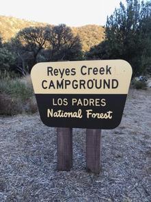
Gene Marshall-Piedra Blanca (Reyes Creek TH)
Address: Maricopa, California
Cost: Free
About
Gene Marshall-Piedra Blanca Reyes Creek Trail (22W03)
Difficulty: moderate to difficult
Length: 17.9 miles
SESPE WILDERNESS - More information on the Sespe Wilderness: www.wilderness.net [http://www.wilderness.net/NWPS/wildView?wid=544]
National Recreation Trail System - More information, Click HERE [http://americantrails.org/nationalrecreationtrails/03USDAappsNRT.html]
Maps: Tom Harrison - Sespe Wilderness Map or 7.5 minute USGS topographic maps (Reyes Peak)
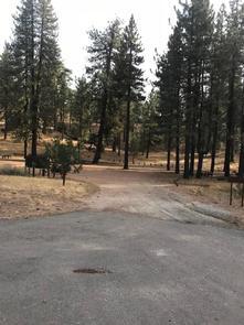
Start from the Reyes Creek Trailhead (elev. 4000 ft., with paved parking, vault toilet and small pipe corral) at the end of Forest Service Rd. 7N11 (Camp Scheideck Rd.). The trail ascends an unnamed drainage for 2.5 miles through oak and chaparral until reaching a saddle and then descending 0.5 miles towards Reyes Creek and Upper Reyes camp (elev. 4675 ft.). This camp has 2 stoves, one on either side of the year-round creek.
The trail continues southeast, ascending a ridge for 1.5 miles before descending towards Beartrap Creek and Beartrap camp (elev. 5100 ft.) in 0.3 miles. Beartrap camp has 5 stoves amidst cedars, alders and conifers; water is year-round.
The trail continues 2.8 miles southeast, following the creek until climbing to a saddle (elev. 6200 ft.) and then gradually descending along the headwaters of Piedra Blanca Creek to Haddock camp (elev. 6100 ft.) in 0.7 miles. This camp, set among conifers, has 4 stoves; water is generally reliable during early summer.
The Reyes Peak Trail 23W04 heads west from just upstream of Haddock camp ascending Reyes Peak until reaching Reyes Peak Trailhead (elev. 6980 ft.) in 5.8 miles. Continue southeast from Haddock camp approximately 2 miles, finally descend into Three Mile camp (elev. 5900 ft.). This camp has 3 stoves; water is generally reliable during early summer.
The trail leaves the main drainage in about .3 miles then undulates in and out of tributaries canyons for another 1.5 miles until it reaches Pine Mountain Lodge camp (elev. 6000 ft.). Pine Mountain Lodge camp has 3 fire rings water is generally reliable during the early summer but a small upstream spring can generally be relied on year-round.
The Cedar Creek Trail (21W10) heads east from Pine Mountain Lodge camp and climbs 1.3 miles to a saddle (elev. 5960 ft.) before dropping into the Piru Creek headwaters towards either Fishbowls or Cedar Creek Trailheads.
From Pine Mountain Lodge camp the trail begins a rapid descent, leaving behind the conifers and transitioning to oaks and chaparral. After 3.3 miles the trail reaches Twin Forks camp (elev. 3620 ft.), just upstream of Piedra Blanca’s north and main forks. This camp has one stove and water is reliable. Continue downstream only 0.25 miles and Piedra Blanca camp is reached (elev. 3550 ft.). This camp has 3 stoves and water is reliable.
From Piedra Blanca camp follow the trail south passing through the rock formation for which this trail is trail is named until reaching the Middle Sespe Trail (22W04) junction (elev. 3100 ft.). Head southeast for 0.4 miles until reaching another trail junction then turn southwest, crossing Sespe Creek to the Piedra Blanca Trailhead (elev. 3040 ft., with paved parking, vault toilets, and one pipe corral in 0.4 miles.
Places nearby:
The pursuit is happiness.
Sekr connects travelers to the campsites, community and journey they are seeking.
The pursuit is happiness.
Sekr connects travelers to the campsites, community and journey they are seeking.


