


Shrine Ridge #2016
Cost: Free
About
The Shrine Ridge trail begins at Shrine Pass Road #709 and ends at Shrine Mountain Ridge. Follow the trail southwest as it climbs through pine-studded meadows. After about 1.3 miles the trail turns west heading through pine forest before the steepest part of the climb to the saddle to the west of you. From the saddle turn right and travel northwest to Shrine Mountain where you can enjoy spectacular 360-degree views.
Named “ Shrine” for its excellent view of the Mount of the Holy Cross,the pass was originally a Ute Indian trail and later used by silver miners and settlers. Views from Shrine Mountain include:
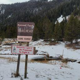
* North - Gore Range,
* Northwest - Uneva Peak,
* Southeast - Copper Mountain ski area,
* South - Ptarmigan Hill and Ptarmigan Pass,
* Southwest - Sawatch Range and Mount of the Holy Cross,
* West - The Flat Top Mountains.
View a printable Recreation Quicksheet for this trail [../../../../../../../../../../Internet/FSE_DOCUMENTS/stelprdb5186390.pdf] which is complete with directions, a map, details, and other information about this trail.
Places nearby:
The pursuit is happiness.
Sekr connects travelers to the campsites, community and journey they are seeking.
The pursuit is happiness.
Sekr connects travelers to the campsites, community and journey they are seeking.


